Download præsentationen
Præsentation er lastning. Vent venligst

1
Satellitter og Satellitdata
Remote sensing

2
Satellitter Hvor er satellitterne – lige nu? Se her:
Geostationær bane GPS Jordnære og polare satellitter De meget elliptiske baner … og alle de hemmelige

3
Satellitdata Færdige programpakker Program i GLOBE-regi
Google Earth ( NASA World Wind ( Program i GLOBE-regi MultiSpec ( Satellit-tracker ( )
")
4
LANDSAT-billeder Her kan man hente billeder
Og her kan du hente en manual og nogle data i fædigbehandlede sæt En vældig fin tutor i brug af MultiSpec

5
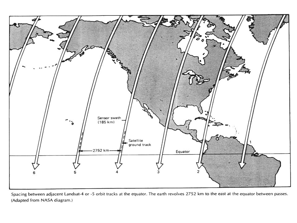
LANDSAT

6
LANDSAT

11
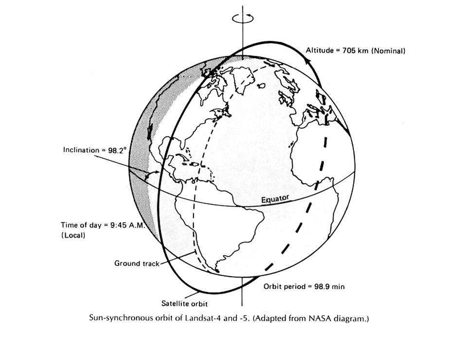
Landsat Satellite

15
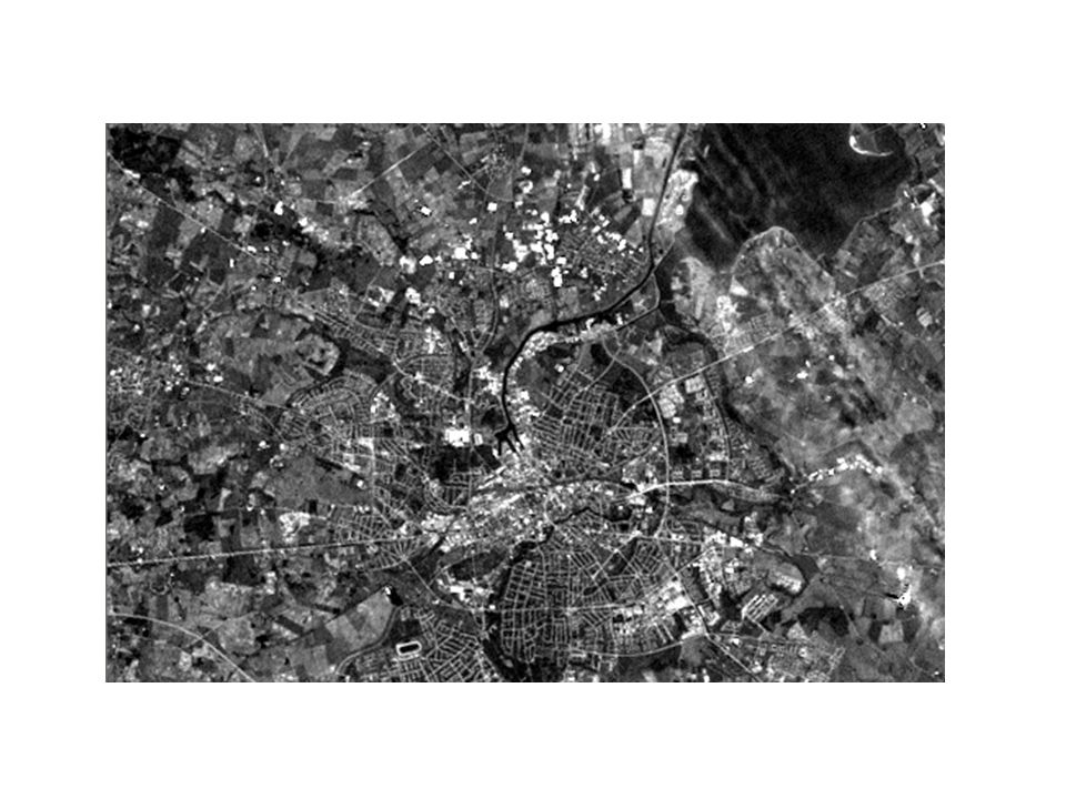
Data fra Landsat og andre satellitbaserede sensorer ankommer til Jorden på digital form:
Men nuller og 1-taller er vanskelige at fortolke, så de omsættes til billeder af computere. Hvis hver pixel tildeles en gråtone svarende til en talværdi, får vi et billede, der minder om et sort-hvidt forotgrafi.

17
Landsat Kanaler

18
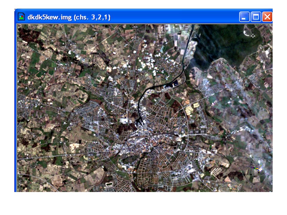
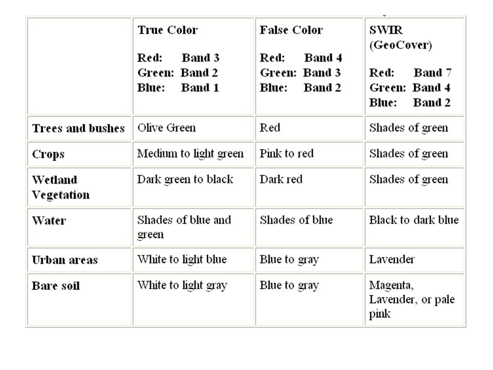
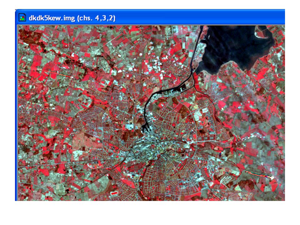
Farver i Landsat billeder
Farve Kanal Resultat Rød (Rød) Grøn (Grøn) ‘True Blå (Blå) Colour’
 Grøn 2 (Grøn) ‘True. Blå 1 (Blå) Colour’")
19
Blåt billede Grønt billede Rødt billede Landsat billede Farve ‘True Colour’ billede

21
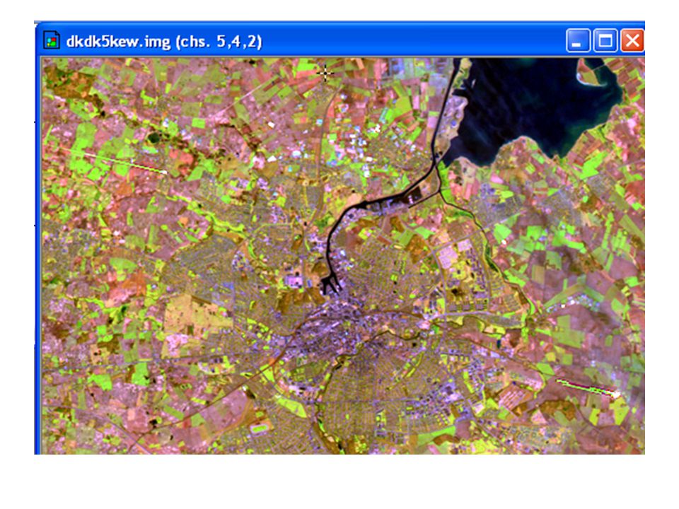
Farve i Landsat Billeder
Farve Kanal Resultat Rød (Near IR) Grøn (Rød) ‘Falsk Blå (Grøn) Farve’
 Grøn 3 (Rød) ‘Falsk. Blå 2 (Grøn) Farve’")
24
What is MultiSpec? MultiSpec is free software for Macintosh and PC computers. MultiSpec allows digital manipulation of Landsat images - Zoom in/out - Examine different band combinations - Examine spectral properties of pixels/groups of pixels MultiSpec is used to produce the computer assisted land cover map in the advanced protocols.

25
Hvilke opløsning kan satelliter måle?
eller Hvor store er pixels?

26
100 meter resolution

27
30 meter resolution

28
5 meter resolution

29
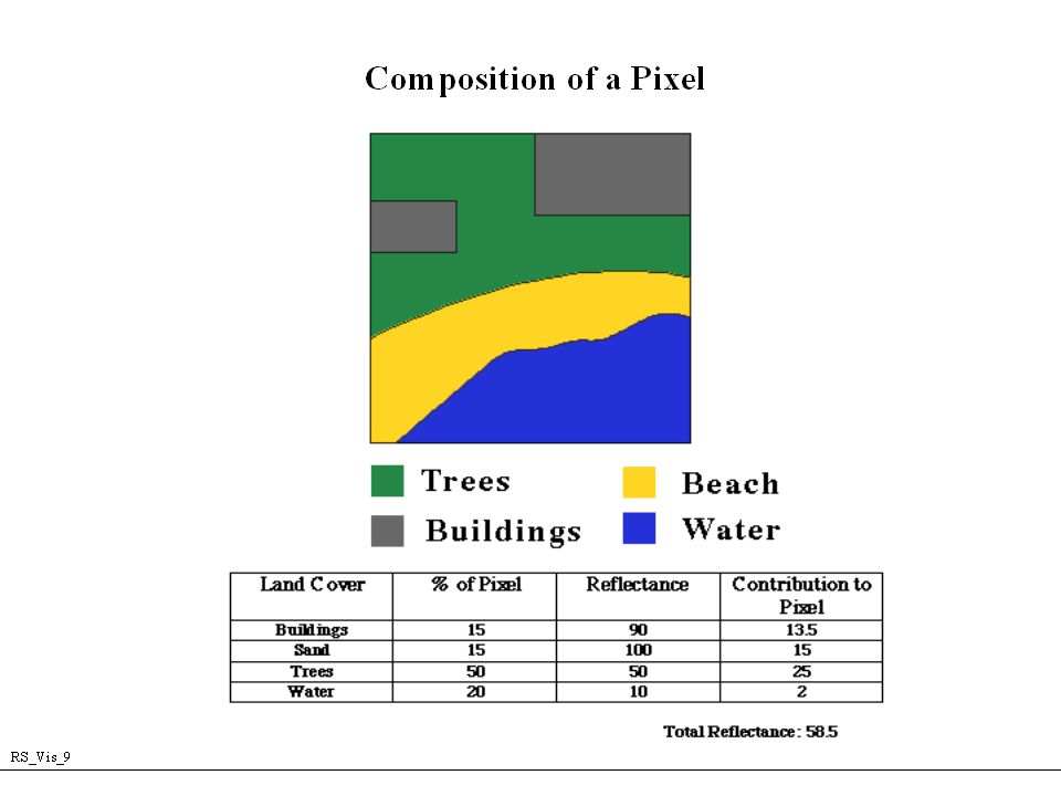
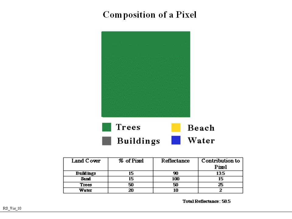
Hvad er i en Pixel? 30m
![]()
32
What is MUC? MUC – Modified UNESCO Classification
Classification system for land types of the world Hierarchical - starts with 10 major Land Classes (coded 0 - 9) 8 Natural Land Cover Classes - 7 types of biomes plus open water 2 Developed Land Cover Classes Rules and definitions in the MUC Field Guide
 8 Natural Land Cover Classes - 7 types of biomes plus open water. 2 Developed Land Cover Classes. Rules and definitions in the MUC Field Guide.")
33
What is MUC? MUC MUC Level 1 Class Code Class 0 Closed Forests
Class 1 Woodlands Class 2 Shrubland or Thicket Class 3 Dwarf Shrubland or Dwarf Thicket Class 4 Herbaceous Vegetation Class 5 Barren Class 6 Wetland Class 7 Open Water Class 8 Cultivated Land Class 9 Urban

34
Land Cover Sampling A Landsat Pixel is 30m x 30m…
and a Land Cover Sample Site is also 30m x30m Land Cover Sample Sites are at the centre of a 90m x 90m area of homogenous Land Cover Ideally, you can take at least one Land Cover Sample at for every type of Land Cover found in your Study Area
![]()
35
Why is the area 90m x 90m? We need to compare each ground site with a pixel in the Landsat image. Our GPS readings are accurate to about ± 30 meters. Satellite ground tracks do not exactly cover any one 30 meter by 30 meter site If an area is homogeneous over a 90 m x 90 m area, the Landsat image and the Land Cover Site can be aligned
![]()
36
What is homogeneous? Land that has the same Land Cover type
- it is uniform

37
(the 15km x 15km area shown in the satellite image)
1222 Site 1 92 Site 2 1121 Site 3 Site 4 91 Site 5 Site 6 Site 7 Site 8 Land Cover is determined at many Sample Sites throughout the Land Cover Study area (the 15km x 15km area shown in the satellite image)
")
38
Referencer Materiale fra GLOBE
Film om elektromagnetisk stråling og refleksion fra forskellige overflader (Remote sensing) Forskellige illustrationer Dr. Andy Tasker, GLOBE, har leveret nogle af de viste slides.
 Forskellige illustrationer. Dr. Andy Tasker, GLOBE, har leveret nogle af de viste slides.")
Lignende præsentationer